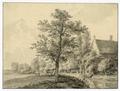
Images Filters Artist Jacobus Versteegh Collection Collection... HET Utrechts Archief (33) British Museum (1) Country Country... Netherlands (34) Continent Continent... Europe (34) Medium No options available Category Category... Buildings & Architecture (29) Landscapes & Seascapes (5) Date Date... 1600-1699 (1) 1700s (1) 1750s (17) 1760s (11) 1770s (15) 1780s (11) 1790s (8) 1800s (2) Jacobus Versteegh 34 matching results. See slideshow Sort orderRelevanceOldest additions firstNewest additions firstOldest painted firstNewest painted first See results on a map View map View of the Kromme Rijn with two farms on the north bank. With a bridge over the mouth of the Oudwulvense Wetering, mill on the Bijlhouwerstoren and the Domtoren. (1757-1759) + Add to album View of the Vleutenseweg with the St.-Jobsgasthuis, from the northeast. (03 September 1756) + Add to album View of the Vecht outside of Utrecht with De Klop inn and Zuylen castle in the background. (1779) + Add to album View of the forecourt of the Hof Provinciaal in the former St. Paul's Abbey. With the buildings on Hamburgerstraat and the gateway on Korte Nieuwstraat. (June 1755) + Add to album The western part of the Nicolaikerk on the Nicolaaskerkhof from the southwest, with the buildings of the former St. Nicolaasklooster and the Gronsveltkameren (09 September 1756) + Add to album View of a bridge in a rural area in Oudwijk outside Utrecht, with the Dom tower in the background. (1771) + Add to album View over the outer canal on the city wall from the east, with the Weerdpoort and bridge and lowered Bok tower in front. (1760-1790) + Add to album View across the outer city canal from the north-west with the Vos tower and the Plompetoren behind the city wall with the mouth of the Plompetorengracht. (1757) + Add to album View across the outer city canal from the east. (07 July 1757) + Add to album View across the outer city canal of the Wittevrouwenpoort, from the northeast. With the corner of the Wolvenburg stronghold and the roof of the Hond tower. (1761) + Add to album View over the Stadsbuitengracht of the Stadwal from the northeast. (1758) + Add to album View of the Oosterstroom in Utrecht from the south, with the wall of the Bemuurde Weerd on the left; in the background the city whirligig. (1760-1790) + Add to album View of the Mariaplaats from the north with the covered market place, on the left the start of the Springweg and on the right a part of the choir of the Mariakerk. (1755-1790) + Add to album View of the Kromme Rijn with a farm and a shed on the other side of the water. (10 September 1756) + Add to album View in the Breedstraat from the west (1756) + Add to album View of the Oudegracht from a window of a house at the Bakker Bridge, from the southeast. With houses Groot Blankenburg, Fresenburg, Groot and Klein Honenburg. (1774) + Add to album View from the Stadsbuitengracht from the west. With the Catharijnepoort and De Fortuin mill. (1750-1780) + Add to album View from the canal with the bridge over the mouth of the Minstroom. (1750-1790) + Add to album View of the Oudegracht from the west from a house at the Bakkerbrug. With the Bezembrug and the house Keijserrijk on the Stadhuisbrug. (1776) + Add to album View of the Oudegracht in Utrecht from the north with the houses on the Stadhuisbrug. (1750-1780) + Add to album View of the southwest corner of the Janskerkhof from the east with the Statenkamer in the background. (1750-1790) + Add to album The southeast corner of the Janskerkhof from the north. With the houses along the Drift with the Maarsberger bridge and the Stammets bridge. (1750-1790) + Add to album View of the Cuneralaan on the north side of the Lower Rhine at the foot of the Heimenberg. (1781) + Add to album View of the Marsdijk, with the city of Rhenen, the Koningshuis and the Cunera tower on the left in the background. (1776) + Add to album View of De Haar castle at Haarzuilens from the east, with the chapel on the left. (1775) + Add to album The ruined castle De Haar in Haarzuilens from the northwest. (1755) + Add to album View of the derelict castle De Haar near Haarzuilens from the east. (1780-1800) + Add to album View of the derelict castle De Haar near Haarzuilens from the northwest. (1780-1800) + Add to album View over the Eem at Eemnes-Buiten, from the southeast. (1771) + Add to album View of the Kromme Rijn near Wijk bij Duurstede with on the right bank a part of a house with a stepped gable. (1765) + Add to album View of the Kromme Rijn near Bunnik with on the right a partially visible farm with a haystack. (12 September 1765) + Add to album Harmelen House (25 June 1756) + Add to album View over the old harbor with market field at the end of the Eemnesservaart in the village of Eemnes-Buiten, from the southeast. (1771) + Add to album Untitled (A view of Utrecht with het Huis Bellevue: landscape/cityscape with parkland beside a canal) (17th Century) + Add to album 1 View of the Kromme Rijn with two farms on the north bank. With a bridge over the mouth of the Oudwulvense Wetering, mill on the Bijlhouwerstoren and the Domtoren. (1757-1759) Image courtesy HET Utrechts Archief | Publiek Domein 1.0 View of the Vleutenseweg with the St.-Jobsgasthuis, from the northeast. (03 September 1756) Image courtesy HET Utrechts Archief | Publiek Domein 1.0 View of the Vecht outside of Utrecht with De Klop inn and Zuylen castle in the background. (1779) Image courtesy HET Utrechts Archief | Publiek Domein 1.0 View of the forecourt of the Hof Provinciaal in the former St. Paul's Abbey. With the buildings on Hamburgerstraat and the gateway on Korte Nieuwstraat. (June 1755) Image courtesy HET Utrechts Archief | Publiek Domein 1.0 The western part of the Nicolaikerk on the Nicolaaskerkhof from the southwest, with the buildings of the former St. Nicolaasklooster and the Gronsveltkameren (09 September 1756) Image courtesy HET Utrechts Archief | Publiek Domein 1.0 View of a bridge in a rural area in Oudwijk outside Utrecht, with the Dom tower in the background. (1771) Image courtesy HET Utrechts Archief | Publiek Domein 1.0 View over the outer canal on the city wall from the east, with the Weerdpoort and bridge and lowered Bok tower in front. (1760-1790) Image courtesy HET Utrechts Archief | Publiek Domein 1.0 View across the outer city canal from the north-west with the Vos tower and the Plompetoren behind the city wall with the mouth of the Plompetorengracht. (1757) Image courtesy HET Utrechts Archief | Publiek Domein 1.0 View across the outer city canal from the east. (07 July 1757) Image courtesy HET Utrechts Archief | Publiek Domein 1.0 View across the outer city canal of the Wittevrouwenpoort, from the northeast. With the corner of the Wolvenburg stronghold and the roof of the Hond tower. (1761) Image courtesy HET Utrechts Archief | Publiek Domein 1.0 View over the Stadsbuitengracht of the Stadwal from the northeast. (1758) Image courtesy HET Utrechts Archief | Publiek Domein 1.0 View of the Oosterstroom in Utrecht from the south, with the wall of the Bemuurde Weerd on the left; in the background the city whirligig. (1760-1790) Image courtesy HET Utrechts Archief | Publiek Domein 1.0 View of the Mariaplaats from the north with the covered market place, on the left the start of the Springweg and on the right a part of the choir of the Mariakerk. (1755-1790) Image courtesy HET Utrechts Archief | Publiek Domein 1.0 View of the Kromme Rijn with a farm and a shed on the other side of the water. (10 September 1756) Image courtesy HET Utrechts Archief | Publiek Domein 1.0 View in the Breedstraat from the west (1756) Image courtesy HET Utrechts Archief | Publiek Domein 1.0 View of the Oudegracht from a window of a house at the Bakker Bridge, from the southeast. With houses Groot Blankenburg, Fresenburg, Groot and Klein Honenburg. (1774) Image courtesy HET Utrechts Archief | Publiek Domein 1.0 View from the Stadsbuitengracht from the west. With the Catharijnepoort and De Fortuin mill. (1750-1780) Image courtesy HET Utrechts Archief | Publiek Domein 1.0 View from the canal with the bridge over the mouth of the Minstroom. (1750-1790) Image courtesy HET Utrechts Archief | Publiek Domein 1.0 View of the Oudegracht from the west from a house at the Bakkerbrug. With the Bezembrug and the house Keijserrijk on the Stadhuisbrug. (1776) Image courtesy HET Utrechts Archief | Publiek Domein 1.0 View of the Oudegracht in Utrecht from the north with the houses on the Stadhuisbrug. (1750-1780) Image courtesy HET Utrechts Archief | Publiek Domein 1.0 View of the southwest corner of the Janskerkhof from the east with the Statenkamer in the background. (1750-1790) Image courtesy HET Utrechts Archief | Publiek Domein 1.0 The southeast corner of the Janskerkhof from the north. With the houses along the Drift with the Maarsberger bridge and the Stammets bridge. (1750-1790) Image courtesy HET Utrechts Archief | Publiek Domein 1.0 View of the Cuneralaan on the north side of the Lower Rhine at the foot of the Heimenberg. (1781) Image courtesy HET Utrechts Archief | Publiek Domein 1.0 View of the Marsdijk, with the city of Rhenen, the Koningshuis and the Cunera tower on the left in the background. (1776) Image courtesy HET Utrechts Archief | Publiek Domein 1.0 View of De Haar castle at Haarzuilens from the east, with the chapel on the left. (1775) Image courtesy HET Utrechts Archief | Publiek Domein 1.0 The ruined castle De Haar in Haarzuilens from the northwest. (1755) Image courtesy HET Utrechts Archief | Publiek Domein 1.0 View of the derelict castle De Haar near Haarzuilens from the east. (1780-1800) Image courtesy HET Utrechts Archief | Publiek Domein 1.0 View of the derelict castle De Haar near Haarzuilens from the northwest. (1780-1800) Image courtesy HET Utrechts Archief | Publiek Domein 1.0 View over the Eem at Eemnes-Buiten, from the southeast. (1771) Image courtesy HET Utrechts Archief | Publiek Domein 1.0 View of the Kromme Rijn near Wijk bij Duurstede with on the right bank a part of a house with a stepped gable. (1765) Image courtesy HET Utrechts Archief | Publiek Domein 1.0 View of the Kromme Rijn near Bunnik with on the right a partially visible farm with a haystack. (12 September 1765) Image courtesy HET Utrechts Archief | Publiek Domein 1.0 Harmelen House (25 June 1756) Image courtesy HET Utrechts Archief | Publiek Domein 1.0 View over the old harbor with market field at the end of the Eemnesservaart in the village of Eemnes-Buiten, from the southeast. (1771) Image courtesy HET Utrechts Archief | Publiek Domein 1.0 Untitled (A view of Utrecht with het Huis Bellevue: landscape/cityscape with parkland beside a canal) (17th Century) © Trustees of the British Museum | CC BY-NC-SA 4.0