-
Artist
-
Collection
-
Country
-
Continent
-
Medium
-
Category
-
Date
242 matching results. You may want to refine your search.


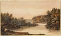
Bay of Marmorice (c. 1801-1803)
 Courtesy of National Gallery of Canada, Ottawa | All Rights Reserved
Courtesy of National Gallery of Canada, Ottawa | All Rights Reserved

Bay of Marmorice (c. 1801-1803)
 Courtesy of National Gallery of Canada, Ottawa | All Rights Reserved
Courtesy of National Gallery of Canada, Ottawa | All Rights Reserved
Bay of Marmorice (c. 1801-1803)
 Courtesy of National Gallery of Canada, Ottawa | All Rights Reserved
Courtesy of National Gallery of Canada, Ottawa | All Rights Reserved


Harbour of Malta (c. 1801-1803)
 Courtesy of National Gallery of Canada, Ottawa | All Rights Reserved
Courtesy of National Gallery of Canada, Ottawa | All Rights Reserved


Harbour of Malta (c. 1801-1803)
 Courtesy of National Gallery of Canada, Ottawa | All Rights Reserved
Courtesy of National Gallery of Canada, Ottawa | All Rights Reserved