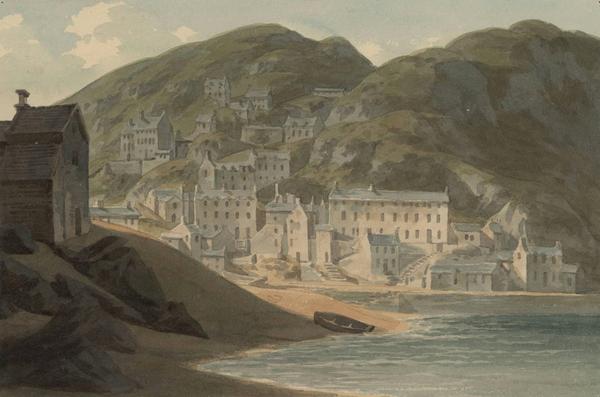
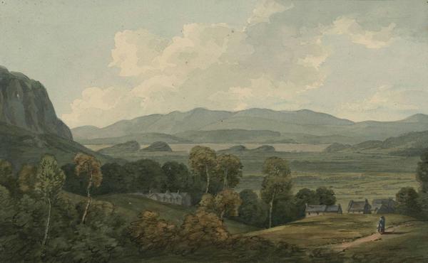
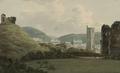
Images Filters Artist John Warwick Smith Collection Collection... The National Library of Wales (160) British Museum (81) Manchester Art Gallery (57) Yale Center for British Art (43) Tate (27) Private Collection (22) Guy Peppiatt Fine Art (13) Rhode Island School of Design (12) Birmingham Museums Trust (4) The Courtauld Gallery (3) Abbot Hall Art Gallery (2) Government Art Collection (2) Museum of New Zealand Te Papa Tongarewa (2) Newport Museum and Art Gallery (2) The Metropolitan Museum of Art (2) Winchester College (2) Ashmolean Museum (1) Chatsworth (1) Chris Beetles Gallery (1) Clive Crowley (1) Eton College Collections (1) Karen Taylor Fine Art (1) Museum of Fine Arts Boston (1) National Galleries of Scotland (1) National Gallery of Art, Washington (1) National Gallery of Canada, Ottawa (1) Royal Watercolour Society (1) Stirling Smith Art Gallery and Museum (1) The Salisbury Museum (1) The Wordsworth Trust (1) York Museums Trust (1) Country Country... Wales (221) Italy (134) England (39) Switzerland (31) France (12) Scotland (4) Panama (2) Germany (1) Luxembourg (1) New Zealand (1) Vatican City (1) Continent Continent... Europe (446) North America (2) Oceania (1) Medium Medium... Watercolour (310) Wash Drawing (1) Category Category... Landscapes & Seascapes (279) Buildings & Architecture (166) Industries & Professions (3) People & Society (1) Date Date... 1600-1699 (4) 1700s (4) 1710s (4) 1720s (4) 1730s (4) 1740s (1) 1750s (78) 1760s (98) 1770s (137) 1780s (291) 1790s (250) 1800s (172) 1810s (104) 1820s (104) 1830s (99) 1840s (5) 1850s (4) 1860s (2) 1870s (2) 1880s (2) 1890s (2) 1900s (2) John Warwick Smith 449 matching results. You may want to refine your search. See slideshow Sort orderRelevanceOldest additions firstNewest additions firstOldest painted firstNewest painted first See results on a map View map View of St Brides Bay on the near approach to it from St Davids & not far from Solvach The southern boudary stretches far out to the westward & is terminated by the island of Skomar divided from the main by Jacks Sound (13 July, 1792) + Add to album [The ruins of Hubberston Priory] (1784-1806) + Add to album The curious little creek of Solva or Solvach, an inlet from St Brides Bay Principally frequented by coasters in the culm & lime trade sometimes an harbour of refuge for vessels in distress, tho[ugh] of difficult access (10 July, 1795) + Add to album View of Milford with its dock yard below it. The Roch fort of 74 guns on the stocks (1784-1806) + Add to album General distant view of the city of Chester surrounded by its walls looking to it from the westwards across the River Dee & the Roodce (1784-1806) + Add to album View in the Valley at Foxley the seat of Uvedale Price, Esq. near Hereford The Luxuriant Woods & varied woodland scenery of Foxley form the characteristic beauty of this residence. Herefordshire (1784-1806) + Add to album General view of the town & castle of Caernarvon from Tut Hill looking westward to the Eifl Hills & to the opening at Abermenai from the sea (12 July 1790) + Add to album Distant general view of Bridgenorth, with the approaching course of the Severn the Wrekin seen in the distance, Shropshire (1784-1806) + Add to album General distant view of Aberystwith & of the bay of Cardigan near this spot tradition has place the grave of Taliessin, but the vestiges of Gwyl Taliessin have totally disappeared, Cardiganshire (1784-1806) + Add to album The slight remains of Holt Castle on the Dee built by John Earl of Warren in the reign of Edwrd.1st the castrum legionis of the Romans an outpost to Deva, the present Chester is generaly fixed at this place, Denbighshire (1784-1806) + Add to album Barmouth, Merionethshire (19 July, 1792) + Add to album Ruins of the Great Hall of Conway Castle connecting with other parts of the ruins taken from the interior (1784-1806) + Add to album The cataract of the Penmachno River not far from its junction with the Conway River near its falls, Carnarvonshire + Add to album The Eagle Tower of Caernarvon Castle seen from across the Menai (1784-1806) + Add to album S. west view of the Brython Hills near Welshpool, with Rodney's Pillar on their highes summit (27 June, 1790) + Add to album Ruins of the Cistertian Abbey of Basingwerk above the Dee near Holywell built about the year 1131, Flintshire (1784-1806) + Add to album Distant general view of Carmarthen, the Caer Myrddin of the Welsh & the Maridunum of the Romans on the river Towey this view was taken from a commanding brow on the road going from Carmarthen towards Green Castle nr. Llanstephan, Carmarthenshire (9 July, 1795) + Add to album View of Pont y Pridd over the impetuous Taafe The extraordinary work of William Edwards the Welsh mason. The diameter of the arch 175 feet -chord 140 -altitude 35. This bridge was completed A.D. 1756. Glamorganshire (2 July, 1795) + Add to album Llanrwst bridge over the River Conway - the work on Inigo Jones (1784-1806) + Add to album [Hafod House] (1784-1806) + Add to album Ruins of Caldicot Castle, Monmouthshire (1784-1806) + Add to album View of Abbey Crucis near Llangollen, North Wales (1804) + Add to album [Cavern cascade] (1784-1806) + Add to album Approach to Llanelly from Kidwelly Llanelly is situated near the Burrey River which falls into Carmarthen Bay. The peninsula of Gower seen in this view (8 July, 1795) + Add to album View of the site & part of the ruins of Abergavennuy Castle Situated above the Gavenny behind it rises the Derry & in the distance over the town is Pen y Vale or the Sugar Loaf Mountain. Monmouthshire (17 July, 1788) + Add to album Tyloge Bridge, Hafod Park (1784-1806) + Add to album In the Vale of Ffestiniog, Merionethshire, N W (1784-1806) + Add to album Aqueduct near Llangollen, Denbighshire, N.W 360 yards long, 40 feet high above the Dee (1784-1806) + Add to album The vale or glen of Penanmaen - in which was the ancient mansion built by Ieuan ap Robert ap Meredith in the reign of Hen[ry] 7th - it opens from the Vale of Dolwyddelen (27 July, 1797) + Add to album The approach to the pass of Penmaenmawr on the road between Conway and Bangor - the island of Anglesea seen across the sea in the distance (1784-1806) + Add to album South east view of the ruins of Skenfrith castle & bridge over the Monnow the founder is unknown, but is supposed to have dated with the earliest castles in Wales. It once belonged to Hubert de Burgh, Earl of Kent. Monmouthshire (11 June, 1790) + Add to album [The ruins of Raglan castle] (1 July, 1795) + Add to album [Cowbridge] (8 July, 1787) + Add to album [The ruins of Newport castle] (26 July, 1787) + Add to album The ruins of Dolwyddelan Castle - the vale above which it stands is watered by the Lledan River - backed to the westward by Moel Siabod (27 July, 1797) + Add to album The Post House at Ponty Dulas (1784-1806) + Add to album [The ruins of Pennard Castle in Gower] (7 July, 1795) + Add to album View near Gwindu in the Island of Anglesea going towards Llanerchmedd, Snowdon in the distance (9 July, 1792) + Add to album The ruins of Castell Coch above the river Taaf This castle is near Llandaff on the road from thence to Pontypridd & Merthyr Tidvil, Glamorganshire (1 August, 1787) + Add to album General view of the ruins of Conway Castle & the river Conway from Mr Hollands grounds called Arcadia (1784-1806) + Add to album Bardsey Island or Ynys Enlli the island in the current, 3 miles from the main seen from Eglwys Vawr near Western terminaton of the Peninsula of Lleyn (23 July, 1795) + Add to album The fall of the Conway River, not far from the cataract formed by the Penmachno River (6 July, 1790) + Add to album View from the road between Bangor & Caernarvon to the western opening of the Menai Strait, seen in the distance (11 July, 1792) + Add to album The ruins of Caernarvon Castle seen near the junction of the Seiont river with the Menai (1784-1806) + Add to album Part of the ruins of Conwy Castle taken from the interior (1784-1806) + Add to album One of the copper mines belonging to the Paris Mountain Company. Anglesea (16 July, 1790) + Add to album Interior of one of the Copper Mines on the Paris Mountain (9 July, 1792) + Add to album General appearance of the copper mines on the Paris Mountain as they appeared in the year 1785. Anglesea (1784-1806) + Add to album One of the copper mines on the Paris Mountain belonging to the Mona Company. Anglesea (10 July, 1790) + Add to album View on leaving Penmorfa looking towards the marsh and the Traethmawr sands (15 July, 1790) + Add to album General distant view of the Brecknock Mountains as seen on the approach to Brecknock from the Hay the outline of these mountains is fine - they are the loftiest in South Wales & are often called the Brecknock Alps. Brecknockshire (14 July, 1795) + Add to album Ruins of Blaen Lleveny Castle at the source of the Lleveny River & which soon after forms Llangorse Pool Seen on the road going towards Talgarth & branching from the Brecknock & Crickhowell road to it. Brecknockshire (19 June, 1790) + Add to album View taken under the ruins of Brecknock Castle looking to Brecknock Bridge & to the course of the River Uske beyond it extending tow[ar]ds Crickhowel. Brecknockshire (12 July, 1788) + Add to album [View of the River Honddy in Brecknock] (13 July, 1788) + Add to album Builth Bridge and site of its castle. Brecknockshire.Wales (1784-1806) + Add to album [The ruins of Brecknock Castle] (8 July, 1788) + Add to album The mountain called Mynydd Mawr - on the road between Caernarvon & Beddgelert - on the near approach to Llyn Cywllyn (15 July, 1792) + Add to album Llynniau Nantlle looking across the lakes to Snowdon through the narrowd gorge into Drws y Coed flanked at its entrance by the Drws y Coed Mountain on the right & Mynydd Mawr on the left (1797) + Add to album General view of the lakes of Llanberis from Cwm Glo above the lower lake looking to Snowdon. Caernarvonshire (3 August, 1797) + Add to album General view of the town & castle of Conway - and of the river Conway - backed by Penmaen Bach & its neighbouring heights - from the ferry on the approach from St.Asaph (1784-1806) + Add to album First Prev12345Next Last View of St Brides Bay on the near approach to it from St Davids & not far from Solvach The southern boudary stretches far out to the westward & is terminated by the island of Skomar divided from the main by Jacks Sound (13 July, 1792) Courtesy of The National Library of Wales | Public Domain [The ruins of Hubberston Priory] (1784-1806) Courtesy of The National Library of Wales | Public Domain The curious little creek of Solva or Solvach, an inlet from St Brides Bay Principally frequented by coasters in the culm & lime trade sometimes an harbour of refuge for vessels in distress, tho[ugh] of difficult access (10 July, 1795) Courtesy of The National Library of Wales | Public Domain View of Milford with its dock yard below it. The Roch fort of 74 guns on the stocks (1784-1806) Courtesy of The National Library of Wales | Public Domain General distant view of the city of Chester surrounded by its walls looking to it from the westwards across the River Dee & the Roodce (1784-1806) Courtesy of The National Library of Wales | Public Domain View in the Valley at Foxley the seat of Uvedale Price, Esq. near Hereford The Luxuriant Woods & varied woodland scenery of Foxley form the characteristic beauty of this residence. Herefordshire (1784-1806) Courtesy of The National Library of Wales | Public Domain General view of the town & castle of Caernarvon from Tut Hill looking westward to the Eifl Hills & to the opening at Abermenai from the sea (12 July 1790) Courtesy of The National Library of Wales | Public Domain Distant general view of Bridgenorth, with the approaching course of the Severn the Wrekin seen in the distance, Shropshire (1784-1806) Courtesy of The National Library of Wales | Public Domain General distant view of Aberystwith & of the bay of Cardigan near this spot tradition has place the grave of Taliessin, but the vestiges of Gwyl Taliessin have totally disappeared, Cardiganshire (1784-1806) Courtesy of The National Library of Wales | Public Domain The slight remains of Holt Castle on the Dee built by John Earl of Warren in the reign of Edwrd.1st the castrum legionis of the Romans an outpost to Deva, the present Chester is generaly fixed at this place, Denbighshire (1784-1806) Courtesy of The National Library of Wales | Public Domain Barmouth, Merionethshire (19 July, 1792) Courtesy of The National Library of Wales | Public Domain Ruins of the Great Hall of Conway Castle connecting with other parts of the ruins taken from the interior (1784-1806) Courtesy of The National Library of Wales | Public Domain The cataract of the Penmachno River not far from its junction with the Conway River near its falls, Carnarvonshire Courtesy of The National Library of Wales | Public Domain The Eagle Tower of Caernarvon Castle seen from across the Menai (1784-1806) Courtesy of The National Library of Wales | Public Domain S. west view of the Brython Hills near Welshpool, with Rodney's Pillar on their highes summit (27 June, 1790) Courtesy of The National Library of Wales | Public Domain Ruins of the Cistertian Abbey of Basingwerk above the Dee near Holywell built about the year 1131, Flintshire (1784-1806) Courtesy of The National Library of Wales | Public Domain Distant general view of Carmarthen, the Caer Myrddin of the Welsh & the Maridunum of the Romans on the river Towey this view was taken from a commanding brow on the road going from Carmarthen towards Green Castle nr. Llanstephan, Carmarthenshire (9 July, 1795) Courtesy of The National Library of Wales | Public Domain View of Pont y Pridd over the impetuous Taafe The extraordinary work of William Edwards the Welsh mason. The diameter of the arch 175 feet -chord 140 -altitude 35. This bridge was completed A.D. 1756. Glamorganshire (2 July, 1795) Courtesy of The National Library of Wales | Public Domain Llanrwst bridge over the River Conway - the work on Inigo Jones (1784-1806) Courtesy of The National Library of Wales | Public Domain [Hafod House] (1784-1806) Courtesy of The National Library of Wales | Public Domain Ruins of Caldicot Castle, Monmouthshire (1784-1806) Courtesy of The National Library of Wales | Public Domain View of Abbey Crucis near Llangollen, North Wales (1804) Courtesy of The National Library of Wales | Public Domain [Cavern cascade] (1784-1806) Courtesy of The National Library of Wales | Public Domain Approach to Llanelly from Kidwelly Llanelly is situated near the Burrey River which falls into Carmarthen Bay. The peninsula of Gower seen in this view (8 July, 1795) Courtesy of The National Library of Wales | Public Domain View of the site & part of the ruins of Abergavennuy Castle Situated above the Gavenny behind it rises the Derry & in the distance over the town is Pen y Vale or the Sugar Loaf Mountain. Monmouthshire (17 July, 1788) Courtesy of The National Library of Wales | Public Domain Tyloge Bridge, Hafod Park (1784-1806) Courtesy of The National Library of Wales | Public Domain In the Vale of Ffestiniog, Merionethshire, N W (1784-1806) Courtesy of The National Library of Wales | Public Domain Aqueduct near Llangollen, Denbighshire, N.W 360 yards long, 40 feet high above the Dee (1784-1806) Courtesy of The National Library of Wales | Public Domain The vale or glen of Penanmaen - in which was the ancient mansion built by Ieuan ap Robert ap Meredith in the reign of Hen[ry] 7th - it opens from the Vale of Dolwyddelen (27 July, 1797) Courtesy of The National Library of Wales | Public Domain The approach to the pass of Penmaenmawr on the road between Conway and Bangor - the island of Anglesea seen across the sea in the distance (1784-1806) Courtesy of The National Library of Wales | Public Domain South east view of the ruins of Skenfrith castle & bridge over the Monnow the founder is unknown, but is supposed to have dated with the earliest castles in Wales. It once belonged to Hubert de Burgh, Earl of Kent. Monmouthshire (11 June, 1790) Courtesy of The National Library of Wales | Public Domain [The ruins of Raglan castle] (1 July, 1795) Courtesy of The National Library of Wales | Public Domain [Cowbridge] (8 July, 1787) Courtesy of The National Library of Wales | Public Domain [The ruins of Newport castle] (26 July, 1787) Courtesy of The National Library of Wales | Public Domain The ruins of Dolwyddelan Castle - the vale above which it stands is watered by the Lledan River - backed to the westward by Moel Siabod (27 July, 1797) Courtesy of The National Library of Wales | Public Domain The Post House at Ponty Dulas (1784-1806) Courtesy of The National Library of Wales | Public Domain [The ruins of Pennard Castle in Gower] (7 July, 1795) Courtesy of The National Library of Wales | Public Domain View near Gwindu in the Island of Anglesea going towards Llanerchmedd, Snowdon in the distance (9 July, 1792) Courtesy of The National Library of Wales | Public Domain The ruins of Castell Coch above the river Taaf This castle is near Llandaff on the road from thence to Pontypridd & Merthyr Tidvil, Glamorganshire (1 August, 1787) Courtesy of The National Library of Wales | Public Domain General view of the ruins of Conway Castle & the river Conway from Mr Hollands grounds called Arcadia (1784-1806) Courtesy of The National Library of Wales | Public Domain Bardsey Island or Ynys Enlli the island in the current, 3 miles from the main seen from Eglwys Vawr near Western terminaton of the Peninsula of Lleyn (23 July, 1795) Courtesy of The National Library of Wales | Public Domain The fall of the Conway River, not far from the cataract formed by the Penmachno River (6 July, 1790) Courtesy of The National Library of Wales | Public Domain View from the road between Bangor & Caernarvon to the western opening of the Menai Strait, seen in the distance (11 July, 1792) Courtesy of The National Library of Wales | Public Domain The ruins of Caernarvon Castle seen near the junction of the Seiont river with the Menai (1784-1806) Courtesy of The National Library of Wales | Public Domain Part of the ruins of Conwy Castle taken from the interior (1784-1806) Courtesy of The National Library of Wales | Public Domain One of the copper mines belonging to the Paris Mountain Company. Anglesea (16 July, 1790) Courtesy of The National Library of Wales | Public Domain Interior of one of the Copper Mines on the Paris Mountain (9 July, 1792) Courtesy of The National Library of Wales | Public Domain General appearance of the copper mines on the Paris Mountain as they appeared in the year 1785. Anglesea (1784-1806) Courtesy of The National Library of Wales | Public Domain One of the copper mines on the Paris Mountain belonging to the Mona Company. Anglesea (10 July, 1790) Courtesy of The National Library of Wales | Public Domain View on leaving Penmorfa looking towards the marsh and the Traethmawr sands (15 July, 1790) Courtesy of The National Library of Wales | Public Domain General distant view of the Brecknock Mountains as seen on the approach to Brecknock from the Hay the outline of these mountains is fine - they are the loftiest in South Wales & are often called the Brecknock Alps. Brecknockshire (14 July, 1795) Courtesy of The National Library of Wales | Public Domain Ruins of Blaen Lleveny Castle at the source of the Lleveny River & which soon after forms Llangorse Pool Seen on the road going towards Talgarth & branching from the Brecknock & Crickhowell road to it. Brecknockshire (19 June, 1790) Courtesy of The National Library of Wales | Public Domain View taken under the ruins of Brecknock Castle looking to Brecknock Bridge & to the course of the River Uske beyond it extending tow[ar]ds Crickhowel. Brecknockshire (12 July, 1788) Courtesy of The National Library of Wales | Public Domain [View of the River Honddy in Brecknock] (13 July, 1788) Courtesy of The National Library of Wales | Public Domain Builth Bridge and site of its castle. Brecknockshire.Wales (1784-1806) Courtesy of The National Library of Wales | Public Domain [The ruins of Brecknock Castle] (8 July, 1788) Courtesy of The National Library of Wales | Public Domain The mountain called Mynydd Mawr - on the road between Caernarvon & Beddgelert - on the near approach to Llyn Cywllyn (15 July, 1792) Courtesy of The National Library of Wales | Public Domain Llynniau Nantlle looking across the lakes to Snowdon through the narrowd gorge into Drws y Coed flanked at its entrance by the Drws y Coed Mountain on the right & Mynydd Mawr on the left (1797) Courtesy of The National Library of Wales | Public Domain General view of the lakes of Llanberis from Cwm Glo above the lower lake looking to Snowdon. Caernarvonshire (3 August, 1797) Courtesy of The National Library of Wales | Public Domain General view of the town & castle of Conway - and of the river Conway - backed by Penmaen Bach & its neighbouring heights - from the ferry on the approach from St.Asaph (1784-1806) Courtesy of The National Library of Wales | Public Domain